3.4.2.1 Sentinel-2 data operations
Index
- Band calculator
- Band subsetting
- Cloud masking
- Cropping
- Gap-filling
- Re-projecting
- Re-sampling
- Sen2cor
| The band calculator can be used to do simple arithmetic or band math between different raster layers. Operations such as caluculating vegetation indices can be perfomed by executing the corresponding formula. |
| Band subsetting can be used to select bands from within the datacube. When requiring only a true color composite the function will retrieve only the red, green and blue bands inorder to reduce unnecessary data download and storage. |
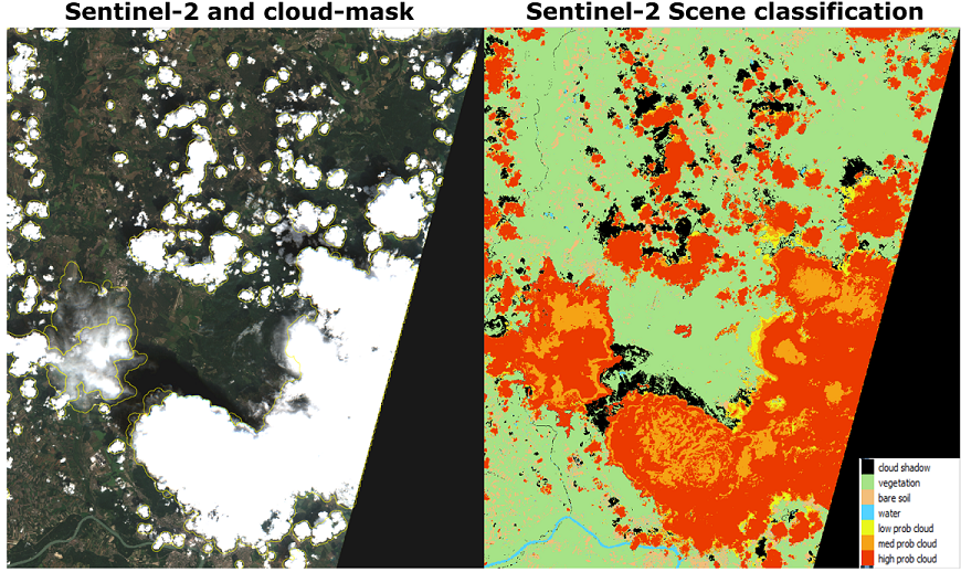
Cloud masking is the action of removing cloud affected pixels, usually by assiging NA values to them. Generally, the precense of clouds or shadows is unavoidable for optical remote sensing and result in missing data. Therefore, negatively affected pixels need to be bemoved, either manually or by applying fully automated setups. To do so cloud mask being produced using a wide range of algorithms, with different ranges of success in detecting clouds and shadows.
|
| Cropping means taking the contents of one dataset (the region of interest) and eliminating all data outside of the area you are studying (the boundary) to yield a smaller new map (the cropped map). Techniques differ depending on whether your source is raster or vector and whether your boundary is defined by another map or by coordinates. |
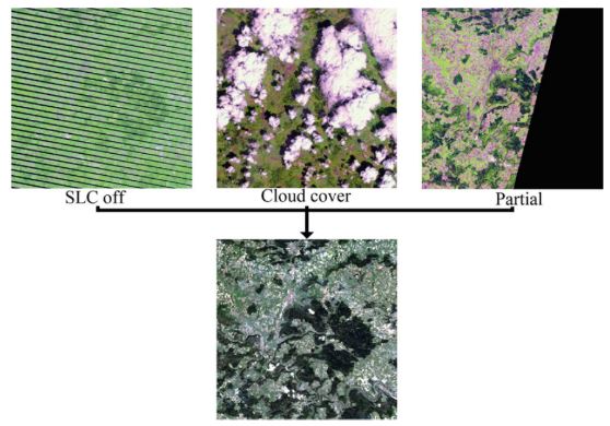
Gap-filling replaces low qulatiy pixels (i.e. clouds, snow, SLC-off) with high quality data from a date near in time or growing season. Severall apporaches have been developed ....
Vuolo, F., Ng, W., Atzberger, C., 2017. Smoothing and gap-filling of high resolution multi-spectral time series: Example of Landsat data. Int. J. Appl. Earth Obs. Geoinformationon 57, 202–213. |
| Re-projecting implies transforming the output to a different map projection. Projection refers to a map projection like UTM. |
| Re-sampling is a broader term where we have data at one resolution, and need values at another (also called scaling). In case we have values at a 100 m x 100 m grid and need values at a 10 m x 10 m grid, the original values will be reused many times, and may be be simply assigned to the nearest high resolution grid cells ("nearest neighbor"), or may be interpolated somehow (e.g. by bilinear interpolation). Resampling from finer to coarser grid by nearest neighbor may again be a special case of aggregation. |
Sen2Cor is a Level-2A processor which main purpose is to correct single-date Sentinel-2 Level-1C Top-Of-Atmosphere (TOA) products from the effects of the atmosphere in order to deliver a Level-2A Bottom-Of-Atmosphere (BOA) reflectance product. Additional outputs are an Aerosol Optical Thickness (AOT) map, a Water Vapour (WV) map and a Scene Classification (SCL) map with Quality Indicators for cloud and snow probabilities. Louis, J., Debaecker, V., Pflug, B., Main-Knorn, M., Bieniarz, J., Mueller-Wilm, U., Cadau, E., Gascon, F., 2016. Sentinel-2 SEN2COR: L2A processor for users. Eur. Sp. Agency, (Special Publ. ESA SP SP-740, 9–13) |