Surface Soil Moisture
Lorem ipsum dolor sit amet, consectetur adipiscing elit, sed do eiusmod tempor incididunt ut labore et dolore magna aliqua. Ut enim ad minim veniam, quis nostrud exercitation ullamco laboris nisi ut aliquip ex ea commodo consequat. Duis aute irure dolor in reprehenderit in voluptate velit esse cillum dolore eu fugiat nulla pariatur. Excepteur sint occaecat cupidatat non proident, sunt in culpa qui officia deserunt mollit anim id est laborum.
Product overview
The base data to retrieve surface soil moisture are from Sentinel-1A VV-polarized backscatter images acquired in Interferometric Wade Swath (IW) mode. The raw satellite data (Level1-data) is jointly provided by the European Space Agency (ESA) and the European Commission (EC). At TU-Wien, the processing of the Level1-data to SSM data is performed as follows:
The Sentinel-1 backscatter is corrected for terrain and resampled to the Equi7 grid. The TU Wien Change Detection model is used to derive soil moisture from backscatter observations. This model was originally developed for the ERS scatterometer and adapted by to the specific measurement configuration of Sentinel-1. In this model, long-term backscatter measurements are used to model the incidence angle dependency of backscatter, which allows a normalization to a common reference incidence angle (![]() ). The relative surface soil moisture estimates range between 0% and 100% and are derived by scaling the normalized backscatter between the lowest/highest backscatter values corresponding to the driest/wettest soil conditions. Soil moisture is represented in the degree of saturation but can be translated from the relative (%) to absolute volumetric units (
). The relative surface soil moisture estimates range between 0% and 100% and are derived by scaling the normalized backscatter between the lowest/highest backscatter values corresponding to the driest/wettest soil conditions. Soil moisture is represented in the degree of saturation but can be translated from the relative (%) to absolute volumetric units (![]() ) using porosity information. The needed parameters dry reference, slope and sensitivity are obtained from Sentinel-1 time series.
) using porosity information. The needed parameters dry reference, slope and sensitivity are obtained from Sentinel-1 time series.
Product description
The surface soil moisture estimate (SSM) represents the topmost soil layer (< 5 cm) and is given in degree of saturation ![]() , ranging from 0% (dry) to 100% (wet).
, ranging from 0% (dry) to 100% (wet). ![]() can be converted into (absolute) volumetric units
can be converted into (absolute) volumetric units ![]() with the help of soil porosity information.
with the help of soil porosity information.
![]()
where is absolute soil moisture in ![]() ,
, ![]() is porosity in
is porosity in ![]() . As it can be seen in the equation above, the accuracy of soil porosity is as much as important as the relative soil moisture content. The SSM images are encoded with the scale factor of 2 (e.g. SSM of 75.5% corresponds to pixel value of 145).
. As it can be seen in the equation above, the accuracy of soil porosity is as much as important as the relative soil moisture content. The SSM images are encoded with the scale factor of 2 (e.g. SSM of 75.5% corresponds to pixel value of 145).
Areas without SSM measurements during the day have no data value of 255. Areas where SSM retrieval is not possible are masked out. The pixel data value is then set to 255 (no data value). Those areas include:
- permanent water
- areas with low sensitivity for SSM (e.g. urban areas)
- steep terrain
Product variables
The Sentinel-1 product comprises the surface soil moisture variable. The following subsection and table will give an overview of the data format.
| Name | Scaling factor | Units | Type | Byte size | No -data |
|---|---|---|---|---|---|
| SSM | 2 | % | uint8 | 1 | 255 |
Overview of Sentinel-1 parameters.
Area and Time Period
SSM has been computing over the area of Austria from 01st January 2016 to the present.
Temporal resolution
SSM images are computed for every orbital overpass separately. There are Ascending (A) and Descending (D) overpasses. This means that each Sentinel-1 SSM image represents one overpass, and multiple overpasses can be averaged to obtain a mean image.
Image timestamps
The date, timestamp and direction of the SSM image acquisition can be found in the image file name. They can also be found in the metadata header of the original GeoTiff file.
Spatial resolution and sampling
Originally, the SSM images are tiled and georeferenced using the TU Wien Equi7(see Data specifications and formats) and have easting and northing coordinates with pixel spacing of 500m which correspond to a resolution of 1km.
Data Format
The SSM data is originally stored and delivered in GeoTIFF format. GeoTIFF is a standard which allows to store georeferencing information within a TIFF raster image. For each day where Sentinel-1 SSM data is available a GeoTIFF is created with the SSM measurements.Paragraph 2
Lorem ipsum dolor sit amet, consectetur adipiscing elit, sed do eiusmod tempor incididunt ut labore et dolore magna aliqua. Ut enim ad minim veniam, quis nostrud exercitation ullamco laboris nisi ut aliquip ex ea commodo consequat. Duis aute irure dolor in reprehenderit in voluptate velit esse cillum dolore eu fugiat nulla pariatur. Excepteur sint occaecat cupidatat non proident, sunt in culpa qui officia deserunt mollit anim id est laborum.
Sub-paragraph
Lorem ipsum dolor sit amet, consectetur adipiscing elit, sed do eiusmod tempor incididunt ut labore et dolore magna aliqua. Ut enim ad minim veniam, quis nostrud exercitation ullamco laboris nisi ut aliquip ex ea commodo consequat. Duis aute irure dolor in reprehenderit in voluptate velit esse cillum dolore eu fugiat nulla pariatur. Excepteur sint occaecat cupidatat non proident, sunt in culpa qui officia deserunt mollit anim id est laborum.
Limitations and caveats
The current algorithm to retrieve SSM from Sentinel-1 does not account for vegetation dynamics. This can lead to biases in the soil moisture which vary with vegetation dynamics. Soil moisture cannot be retrieved over deserts and high vegetation areas like tropical forests. Although a terrain correction is performed, it does not completely remove the influence of topography. Especially over high mountain ranges this limitation comes into effect. In addition, no reliable soil moisture measurements can be done during frozen or snow covered conditions. At the moment no mask or flag is in place for these conditions (e.g. frozen soil, snow cover, open water) and thus it is left to the user to judge whether the SSM data is meaningful or not. Users are advised to to use the best auxiliary data available to improve the flagging of snow, frozen soil and (temporary) standing water. However, under the following conditions a SSM retrieval from Sentinel-1 should be most suited: low to moderate vegetation regimes, unfrozen and no snow, low to moderate topographic variations, no wetlands and coastal areas.
Linear artefacts can be seen in the individual SSM images. Although a calibration is performed by ESA on the three parallel sub-swaths, a number of orbits are still affected by scalloping (a bias in the backscatter per sub-swath). Although visually un-appealing to the user, the error is of low magnitude and has only little effect on the temporal signal.
Lastly, some images are affected by Radio Frequency Interference (RFI) stemming from ground based C-band transmitting systems. Unfortunately, the RFI cannot be removed by ESA or by the SSM algorithm.

Sentinel-1 SSM image over eastern Poland on 04/10/2014. Scalloping causes jumps in the soil moisture images, along the edges of the backscatter image’s sub-swaths.
Surface Soil Moisture
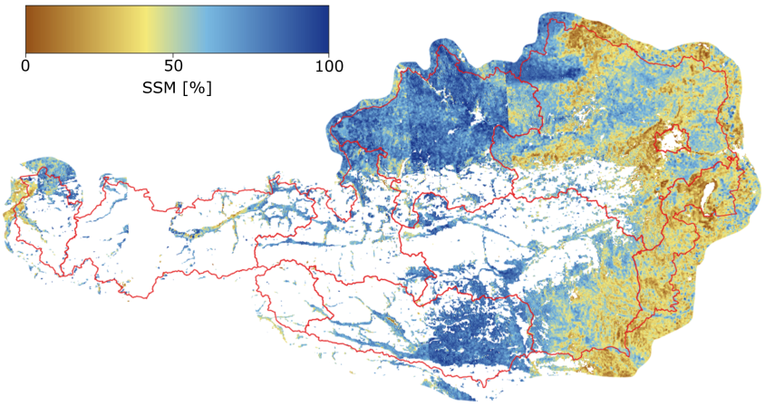
Sentinel-1 SSM product at 500m spatial sampling over Austria from 02.08.2016 to 10.08.2016.
| Product Name | Surface Soil Moisture |
|---|---|
| Category | Sentinel-1 products |
| Spatial Sampling | 500m |
| Temporal Resolution | 3-4 days |
| Unit | Degree of Saturation (%) |