3.4.1.3.5. Surface Soil Moisture
TU Wien Surface Soil Moisture product measures the soil moisture of the very top soil layer (0-5cm). The product derived by using the TU Wien Change Detection Method on a time-series of Sentinel-1 high-resolution images.
Product overview
The base data to retrieve the surface soil moisture (SSM) are from Sentinel-1 VV-polarized backscatter images acquired in Interferometric Wade Swath (IW) mode. The input satellite data is jointly provided by the European Space Agency (ESA) and the European Commission (EC) and retrieved directly via the Central Institution for Meteorology and Geodynamics, Austria (ZAMG). The processing of the input data to SSM data is performed as follows:
The high-resolution DEM for Austrian region is used for the correction of the terrain's influences on the backscatter images. It has a great influence on the creation of a higher-resolution slope, which is an important parameter for SSM retrieval.
The terrain-corrected Sentinel-1 backscatter images is then resampled to the Equi7 grid. The TU Wien Change Detection model is used to derive soil moisture from backscatter observations. This model was originally developed for the ERS scatterometer and adapted to the specific measurement configuration of Sentinel-1. In this model, long-term backscatter measurements are used to model the incidence angle dependency of backscatter, which allows a normalisation to a common reference incidence angle (![]() ). The relative surface soil moisture estimates range between 0% and 100% and are derived by scaling the normalised backscatter between the lowest/highest backscatter values corresponding to the driest/wettest soil conditions. Soil moisture is represented in the degree of saturation but can be translated from the relative (%) to absolute volumetric units (
). The relative surface soil moisture estimates range between 0% and 100% and are derived by scaling the normalised backscatter between the lowest/highest backscatter values corresponding to the driest/wettest soil conditions. Soil moisture is represented in the degree of saturation but can be translated from the relative (%) to absolute volumetric units (![]() ) using porosity information. The needed parameters dry reference, slope and sensitivity are obtained from Sentinel-1 time series.
) using porosity information. The needed parameters dry reference, slope and sensitivity are obtained from Sentinel-1 time series.
Product description
Product variables
The Sentinel-1 product comprises the surface soil moisture variable. The following subsection and table will give an overview of the data format.
| Name | Scaling factor | Units | Type | Byte size | Pixel size (m) | No-data |
|---|---|---|---|---|---|---|
| SSM | 2 | % | uint8 | 1 | 10,10 | 255 |
Overview of Sentinel-1 parameters.
Area and time period
SSM has been computing over the area of Austria from 01st January 2016 to the present.
Temporal resolution
SSM images are computed for every orbital overpass separately. There are Ascending (A) and Descending (D) overpasses. This means that each Sentinel-1 SSM image represents one overpass, and multiple overpasses can be averaged to obtain a mean image. Within this project, A repetition date of up to 3-4 days is expected for the Austrian region.
Image timestamps
The date, timestamp and direction of the SSM image acquisition can be found in the original image file name. They can also be found in the metadata header of the original GeoTiff file.
Spatial resolution and sampling
Originally, the SSM images are tiled and georeferenced using the TU Wien Equi7(see Data specifications and formats) and have easting and northing coordinates with pixel spacing of 500m which correspond to a resolution of 1km.
Data format
The SSM data is originally stored and delivered in GeoTIFF format for Data Cube ingestion. GeoTIFF is a standard which allows storing georeferencing information within a TIFF raster image. For each day where Sentinel-1 SSM data is available, a GeoTIFF is created with the SSM measurements.
Quality Assessment
Masking before resampling
The masking of outliers before resampling is necessary since high scatterers on the 10m scale pollute the 500m pixels when resampling in the linear domain. The figure below illustrates the impact of masking on the re-sampled images. On the left, we see the effect of very high backscatter (white) in cities and villages that are very distinct and very low backscatter values (black) over rivers and lakes, which were not masked out. On the right, the river was masked out in areas where it covers the whole 500m pixel and the city impact on surroundings is attenuated after masking the highest values.
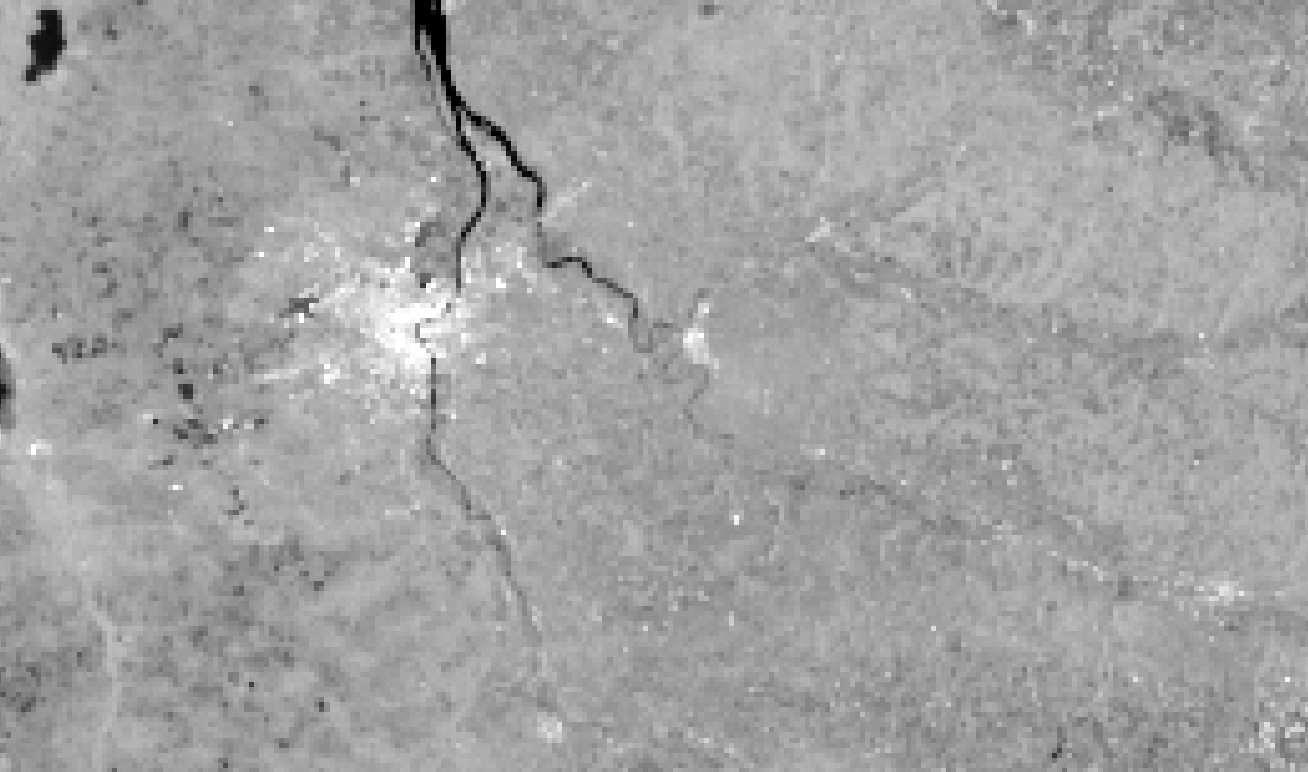 | 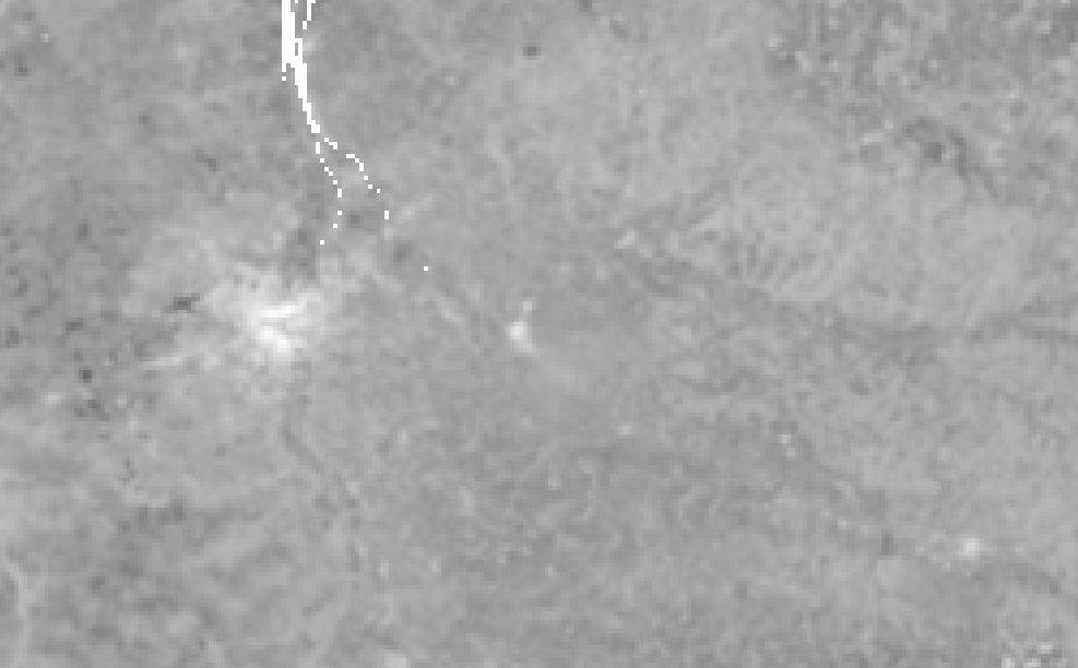 |
Left: Resampled Sentinel-1 backscatter image without masking; right: resampled Sentinel-1 backscatter image with masking.
Final product masking
Areas without SSM measurements during the day will be flagged as a no-data value (255). Areas, where SSM retrieval is not possible, are masked out. The pixel data value is then as well set to no-data value (255). Those areas include:
- Permanent water
- The areas with low sensitivity for SSM (e.g. urban areas)
- The areas with steep terrain
Soil moisture noise estimation
The soil moisture noise model that was previously applied to Envisat ASAR data was evaluated by the new Sentinel-1 parameters with encouraging results. Soil moisture noise indicates the level of the reliability of Sentinel-1 SSM for a pixel. For every single SSM image is delivered, there is an attached soil moisture noise image, which has exactly the same coverage, with the value represents the level of the reliability of the original SSM image.
Limitations and caveats
The current algorithm to retrieve SSM from Sentinel-1 does not account for vegetation dynamics. This can lead to biases in the soil moisture which vary with vegetation dynamics. Soil moisture cannot be retrieved over deserts and high vegetation areas like tropical forests. Although a terrain correction is performed, it does not completely remove the influence of topography. Especially over high mountain ranges, this limitation comes into effect. In addition, no reliable soil moisture measurements can be done during frozen or snow-covered conditions. At the moment no mask or flag is in place for these conditions (e.g. frozen soil, snow cover, open water) and thus it is left to the user to judge whether the SSM data is meaningful or not. Users are advised to use the best auxiliary data available to improve the flagging of snow, frozen soil and (temporary) standing water. However, under the following conditions, an SSM retrieval from Sentinel-1 should be most suited: low to moderate vegetation regimes, unfrozen and no snow, low to moderate topographic variations, no wetlands, and coastal areas.
Linear artefacts can be seen in the individual SSM images. Although calibration is performed by ESA on the three parallel sub-swaths, a number of orbits are still affected by scalloping (a bias in the backscatter per sub-swath). Although visually unappealing to the user, the error is of low magnitude and has only little effect on the temporal signal.
Lastly, some images are affected by Radio Frequency Interference (RFI) stemming from ground-based C-band transmitting systems. Unfortunately, the RFI cannot be removed by ESA or by the SSM algorithm.
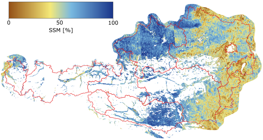
Sentinel-1 SSM product at 500m spatial sampling over Austria from 02.08.2016 to 10.08.2016.
| Product Name | Surface Soil Moisture |
|---|---|
| Code Name | SSM |
| Category | Sentinel-1 products |
| Spatial Sampling | 500m |
| Temporal Resolution | 3-4 days |
| Unit | Degree of Saturation (%) |