3.5.3. Sentinel-1 products
Index
- Processing chain
- Preprocessing
- Parameters
- Products
- Examples
- Monthly mean (MMEN)
- Data composite (M-COMP/S-COMP)
- Surface soil moisture (SSM)
- References
Processing chainThe SAR Geophysical Retrieval Toolbox (SGRT)1 allows to use Sentinel-1A and Sentinel-1B raw data (Level 1, SAFE format) as an input and produce higher level products, such as preprocessed- (Level 2), parameter- (Level 3) and finally value-added product datasets (Level 4) (the naming convention follows the SGRT terminology). SGRT is developed within the microwave remote sensing research group at the Geo Department of TU Wien. PreprocessingThe preprocessed data is derived from the Sentinel-1 raw files with the assistance of the Sentinel Application Platform (SNAP). One raw/SAFE file (i.e. a folder) contains two images for both VV and VH polarisation and metadata being important for further processing steps. These images are available in swath/sensor geometry, which means that the coordinate system is bound to the sensor (azimuth and range), not to Earth (e.g. longitude and latitude). The following steps are necessary to transform this raw data to a reliable representations of backscatter and
After this routine, and depending on the specified settings, the following Level-2 products can be retrieved: SIG0:SIG0 represents the backscatter returned from unit area on ground. GAM0:GAM0 represents the radiometric terrain flattened backscatter returned from unit area on ground, but being projected into the plane perpendicular to the looking the direction. Radiometric terrain flatting takes care of and departs overlapping pulses resulting from the measurements from the side-looking acquisition geometry. ParametersProductsExamplesData composite (M-COMP/S-COMP)Data composites are created by the Remote Sensing Group of TU Wien. A fully customized pre-processing chain is applied to the Sentinel-1 Level 1 SAR data, including calibration, georeferencing, terrain correction, format conversion and compression, quality control, etc. The resulting backscatter data are used and delivered as combinations of either different polarisations (e.g. V/V + V/H) and timely averages (e.g. monthly or seasonal). Additionally, false colour composites are created (e.g. RGB combinations of different polarisations at different times of year). Due to the nature of their visual impression, these composites nicely show the characteristics of the sensor to identify different types of land cover.
Left: Landsat-8 RGB image of London area, UK. Middle: False colour composite (RGB) of Sentinel-1 backscatter data over London area, UK. Red band shows mean of backscatter (VH) during summer (Jun-Jul-Aug), Blue band shows mean of backscatter (VH) during winter (Dec-Jan-Feb), and Green band shows the ratio of the Red and Blue band (mean_summer/mean_winter). Right: False colour composite (RGB) of Sentinel-1 backscatter data over London area, UK. Red band shows mean of backscatter (VV) during winter (Dec-Jan-Feb), Blue band shows mean of backscatter (VH) during winter (Dec-Jan-Feb), and Green band shows the ratio of the Red and Blue band (mean_summer/mean_winter). This composite highlights the variation of backscatter due to different polarizations. |
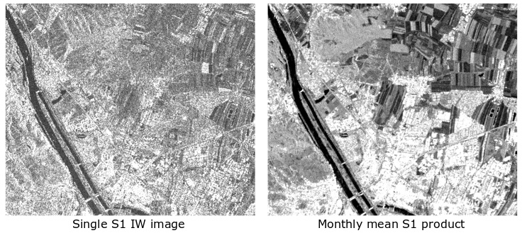
Monthly mean (MMEN)The mean products consits of a single dataset representing the average value per pixel over a defined period. These can be generated at five, ten or monthly intervalls. These higher level products are valuable as single acquisition dates contain abundant noise.
|
Surface soil moisture (SSM)References |
1 Naeimi, Vahid et al. (2016). “Geophysical parameters retrieval from sentinel-1 SAR data: a case study for high performance computing at EODC”. In: Proceedings of the 24th High Performance Computing Symposium. Society for Computer Simulation International, p. 10. |

